Map of the Silk Road: ‘The History of Dunhuang’ — [Dunhuang Academy] — Dunhuang is an oasis surrounded by desert and gravel in northwestern China. It was the main (and only) gateway to and from China on the route, known as the ‘Silk Road’, between China, Western Asia and the sub-continent of India.
LA HISTORIA DE DUNHUANG
Dunhuang es un oasis rodeado de desierto en el norte de China, era el principal y único camino y puerta de entrada de y a China en la Ruta de la Seda, entre China, Asia occidental y el sub continente de la India. Hay muchos mapas de diferentes orígenes que nos muestran la Ruta de la Seda, ve aquí algunos de ellos.
RUTA DE LA SEDA, MAPAS, GALERÍA DE FOTOS
.
Mapa de la Ruta de la Seda
Mapa Ruta de la Seda China a Europa
Antiguo mapa de la Ruta de la Seda
mapa ruta de la seda de Turquestan chino a Turmequistan
Mapa ruta de la Seda Asia
Mapa parte Ruta de la Seda
NatGeo_SilkRoadMap
silk road map
Ancient Silk Road Map
Silk Road Mapchinalandscapes com
Silk Road map land and sea Azerbaijan
Turkish silk road map
silk road maps and arab sea trading routes
Great Wall and Silk Road map
Southern Silk Road China
Silk_Road_Map_interconnections
Early Silk road map from the Ming Dynasty Mongols China and the Silk Road
route de la soie lampas tisse Japon 1865 Musee Historique des Tissus de Lyon
This panorama can be opened in several different resolutions. High resolution panorama with the best quality is about 7 Mb large and it is suitable for fast internet connections and modern computers. For slower internet and old weak computers we created the smaller low resolution panorama. Some small details have been sacrificed but the size of low resolution panorama is nomore than 2 Mb.
Cambodia, exotic state in Southeast Asia, dates back to 612 AD. Its most famous monument is the temple complex of Angkor Wat, but it’s not the only thing to see here. Among other Cambodia landmarks are unspoilt beaches, unique nature, museums, and churches.
The ancient city of Angkor used to be a capital of the ancient Khmer Empire and one of the largest cities in the world. This huge complex of buildings, covering about 600 square kilometers, was known far beyond the Khmer Empire until it was destroyed by Siamese troops in 1431.
Till the end of the XIXth century, more than 100 palaces and temples were concealed under the shadow of lush tropical forest, when a French naturalist Henri Mouhot rediscovered it for humanity. In year 1992 the whole territory of Angkor was taken under the protection of UNESCO.
Angkor became more famous when the blockbuster Lara Croft: Tomb Raider were filmed there. One of the temples Ta Prohm is known even to those who have never traveled to Cambodia before: this is where the most impressive scenes were created.
Angelina Jolie in Lara Croft: Tomb Raider — 2001»
Of course, the scene where sexy heroine fights statues is no more than a fiction. On the contrary, only peace and quiet fills this place and it will be shown in our panoramas next week when the virtual tour «Ta Prohm» is released.
Angkor includes a number of majestic temples complexes, the most famous of which is the «Temple City» of Angkor Wat. It was built as a temple and mausoleum for King Suryavarman II in 1112-1152. It’s considered to be one of the biggest cult buildings in the world.
Angkor Wat is also called a «funeral» temple: the reason for its construction was so that the king’s ashes could be placed there. To simply it, the purpose of this complex is the same as that of pyramids of Egypt.
There is, however, a story about a divine origin of Angkor Wat. Legend has it that the Angkor Wat in Cambodia was built by a son of Hindu god Indra, Khmer King Preh Katomialia. One day he went to the heavenly palace of his father, where everything was perfect, including the barn. He loved the place reserved for the sacred animals so much, that he decided to make its copy on Earth. And that is how a replica of Indra’s barn, Angkor Wat, came to existence.
The complex is, indeed, very majestic. The central tower (with the height of 65 meters) and four small surrounding towers represent the five peaks of the sacred Mount Meru. The giant moat around the temple (190 meters wide and over 5.5 kilometers in length) represents world oceans. A stone-paved road leads to the lavishly decorated temple with a form of a three-level pyramid.
In fact, Angkor Wat alone would be enough for Cambodia to make one of the top countries with the most famous architectural ensembles. But this monument is only a drop in the ocean! ??Angkor has dozens of other incredible places to visit.
For example, Pre Rup is a huge temple mountain dedicated to Shiva. Its name is translated from Khmer language as «turn the body.» At the end of the Xth century Pre Rup was a new capital of the Khmer Empire. The complex is surrounded by a moat and a fence, and the main building is located on a hill. A strange name comes from a cremation ceremony during which the body was rotated on a funeral pyre. But nowadays, having lost its dark atmosphere, it’s considered to be the best place in Cambodia to enjoy the sunset.
Among other grand monuments are Angkor Thom («Great City») and a three-level pyramid of Bayon. From a distance it looks like a bizarre pile of huge stones, but from a closer look you can see amazing bas-reliefs depicting various scenes from the everyday life of the ancient Khmers, and the famous faces of Avalokitesvara, which are executed with such skill that, depending on time of the day and the angle of the sun, they seem to change their expression.
There is also a unique Terrace of the Elephants which was used by Khmer kings as 350 meter high platform to watch ceremonies in the main square of Angkor Thom. In the southern part of Angkor lies West Baray, a giant artificial lake measuring 7 X 1.8 kilometers.
One kilometer east of Angkor Thom is previously mentioned Ta Prohm: a beautiful temple, bound by massive roots of huge trees. Back in the days it was very different: one could see walls decorated by precious stones, hear beautiful music, and dancing in the halls. When in late nineteenth century Ta Prohm was discovered by French, they decided not to conduct a full-scale restoration of the temple. The decision was made due to the fact that giant trees, such as ficus and silk tree, were so merged with ancient walls that eventually they became whole. So now we can see this unique Cambodia monument in the state it was discovered by the researchers.
There is another Khmer capital in Angkor vicinity: Hariharalaya built by Jayavarman II. There are numerous interesting monuments on its territory, including the five-level Bakong temple. Here you can also find Phnom Kulen mountain and Kbal Spean river («Valley of a thousand lingas») with stone phallic symbols and statues of Gods at its bed.
But it’s pointless to give you all these brief descriptions of Cambodia monuments: each one of them deserves its own article. And they say a picture is worth a thousand words: it’s time to see our panorama.
Our tour today is about Angkor Wat temple complex. Other temple tours are to be released in the near future.
Este panorama puede ser abierto en diferentes resoluciones, alta y baja resolución.
Haz click en la imagen y se abre la vista panorámica 360ª, puedes verlo desde diferentes puntos, en cada señal hay una panorámica. El artículo está en ingles, pronto lo traduciré, pero las imágenes hablan por sí mismas.
This panorama can be opened in several different resolutions. High resolution panorama with the best quality is about 7 Mb large and it is suitable for fast internet connections and modern computers. For slower internet and old weak computers we created the smaller low resolution panorama. Some small details have been sacrificed but the size of low resolution panorama is nomore than 2 Mb.
This Virtual Tour is also available in the following formats: – LOW – iPad/Android
Total Views:1 280 755
In January 2008 we photographed Iguazu Falls (also known as Iguassu and Iguaçu) located on the border of Argentina and Brazil. This was one of the first AirPano virtual tours. We got only two aerial panoramas in the tour, because of local restrictions for shooting from a helicopter. At that time there was the only helicopter company Helisul, located at the Brazilian side. Unfortunately administration of Brazilian Iguazu Falls Park requested 20 thousand US dollars for a permit to open helicopter doors. Obviously, we didn’t have such money, and so I had to struggle shooting spherical panoramas through a small passenger window. Besides, it was prohibited to fly under 500 meters above the waterfalls (which would disturb the nature), as well as crossing the Argentinean border that runs through the middle of the Iguazu River. These restrictions kept our pilot away from most interesting spots of the waterfall.
I took another attempt in a few days. Available helicopter, however, didn’t have passenger headphones. I had to cancel the flight, because it was critical to communicate with a pilot during our trip. As I was scheduled to leave Brazil on the following day, the director (an old lady) promised me to refund 500 dollars deposit for the cancelled flight. When I returned to Iguazu Falls a year later, the lady conveniently forgot about her promise and I never got my money back.
It was obvious that a large helicopter was not enough to shoot Iguazu Falls properly (especially from the Argentinean side). We decided to take a second chance and sent our RC helicopter team to Iguazu.
Today we present a large virtual tour that includes aerial and ground photographs taken in 2008 and 2012. Visitors can see details of Iuazu Falls that were not available for public before from the bird’s eye view.
And now I give you Stas Sedov, who personally took part in this photo expedition.
Oleg Gaponyuk
Leaving for Iguazu Falls, Dima and I were worried that it would be a dry season.
Dry season in 2006
Big water in 2005
Our mission was to photograph one of the largest waterfalls in the world, and not a little drip of water. Dima planned our trip very well, carefully selecting travel dates. However, no one could imagine that this would be one of the most stressful and exhausting photo shoots in AirPano history…
Here are selected parts of our email communication with colleagues during the trip:
18 June 2012
I arrived to Iguazu Falls. It rains practically non-stop. There were few gaps in the clouds today, but no sun.
I have never seen so much water in the waterfall basin, even though I have been traveling for 10 years. It pours at 3 million liters per second, and the norm is 1,5 million liters per second…
The waterfall is unbelievably cool! A true endless flow of water!
We will figure out how to shoot the waterfall. We have few ideas, but we worry about our equipment very much. Guys, send us some good weather ASAP! We miss the sun a lot!
19 June 2012
It has been raining non-stop since last night. We went to the observation deck under the waterfall. It was impossible to shoot there! I was soaking wet after running there and back! The viewpoint is practically enveloped in a cloud of mist. We have to take this spot off our location list, unfortunately.
Almost entire canyon is covered with think mist created by falling water. In Moscow, you cannot even imagine the way it looks — it is completely different from older Iguazu spherical panoramas.
Here is a video I took with my phone, but it hardly gives justice to what is really happening here:
20 June 2012
Morning. It’s raining again. But we have finally caught our «three rays of sun!»
We have waited for quite awhile on the observation deck; lots of tension, everybody’s stressed. There was even more water comparing to the day before. It was risky. At times we flew the helicopter in a thick water mist, maneuvering between heavy clouds. The equipment is still functional. In 15 minutes after our lucky moment it started to rain again, so we wrapped it up.
There was a funny incident later at night. We decided to get a snack while waiting for the sun. Dima bought few packs of cookies and a can of soda in a café near the viewpoint, and left it all on a table. We looked away for a moment and immediately heard a light crunch. We didn’t understand what it was at first. Quick look at the table — the cookies are gone! Everything disappeared, but the tail of a little thief running for cover in a nearest shrub. What a vermin! And usually these nosy creatures look so chubby and slow, especially when posing for a camera.
Going to study Iguazu Falls from Argentinean side tomorrow. I checked the footage — there is a chance to get close to the Devil’s Throat.
22 June 2012
We have finally shot Iguazu Falls!
It was the most challenging photo shoot — physically and emotionally — of my entire career. Out of five days of our trip the weather favored us only once, today. We have been [censored] exhausted while waiting for the sun to come out!
We have tried practically all weather improving tricks known to men: throwing coins into the water; sacrificing an old flash card to the waterfalls; Dima even made a personal (much more powerful) sacrifice — he quit smoking! (Ok, it was only for the duration of our trip).
I don’t know which of the tricks finally worked, and who heard our prayers, but today the sun showed up by the end of the day, even if only for a couple of hours. We did our best to make use of this time and to shoot as many locations as possible from the Argentinean side of the waterfalls. Too bad, we didn’t have enough time to photograph everything we wanted.
At night, while processing images, I noticed a peculiar effect — upside-down rainbows! They looked normal from the ground level, but from a higher angle (from a helicopter) a rainbow arches not up, but down. Amazing!
It is raining again outside, so we are going home tomorrow…
23 June 2012
It is late at night, I am writing from the capital of Brazil. We merely made it from Iguazu Falls — as if the waterfall didn’t want to let out team go.
Under the morning rain (as you probably guessed by now) we arrived to the airport to learn that our flight was cancelled. They offered us to take a 4PM flight.
Clouds lifted a bit, and sun picked out for a moment. We grabbed out bags and ran back to the park, to the waterfalls. I assembled our helicopter on the floor in a car rental office while Dima signed papers.
When we entered the park, sun was still out, shining bright. We were very excited. Well, as you can easily imagine, the sky got quickly covered with dark clouds with no hope for an outbreak.
After an hour of waiting I proposed to shoot anyway, while waiting for the sun. Agreed — we take off.
The helicopter flew far away from the observation deck — so scary! Ok, it looks like we’ve got the pictures, time to go back. I land the helicopter and remove the camera to check our «masterpieces.» What the hell? The focusing ring was messed up completely. All images can go down the drain.
Alright! I prepare for the next flight. Now we got a strong wind and light rain. We thoroughly check the camera and lens before take off. Everything is fine.
We take off and start shooting. There was a moment when the helicopter almost crashed due a strong turbulence, but we managed to keep it up. We land and remove the camera — what the hell??? All our camera settings were off! The humidity might have caused it, but we didn’t care — all images could go down the drain again. The following five minutes were filled with loud cursing in Russian. Finally, I tell Dima «The waterfall simply doesn’t want to surrender to us. Let’s wrap it up before we crash the helicopter.» Dima agreed.
Well, we couldn’t help it and stayed for another 15 minutes or so. There was an opening in the clouds. What do you think? We flew one more time.
It was probably the most thorough and precise pre-flight check we have ever done. We checked every single detail three times. While at it, a heavy cloud of mist came from the waterfall and we were forced to take the helicopter higher to keep the lens relatively dry.
Fortunately, this flight went well. We quickly packed our gear and left for the airport under heavy raindrops.
In the airport we found out that our flight was delayed for another hour and a half, so our trip to Iguazu Falls turned to be one day longer. There was no more sunlight. On the way back, when I looked out of an airplane window, everything was covered with clouds. It was raining again at Iguazu…
Iguazu Falls in South America crowns the final stretch of the river bearing the same name. Fifteen kilometers downstream from the waterfalls, the Iguazu River (also known as Iguassu or Iguaçu) empties into another waterway of the continent — the Paraná River. Both create a sort of T-shaped crossroads where the three Latin American states come together: Argentina, Paraguay, and Brazil. Huge frontier markers on the three riverbanks are painted in the national colors of the respective nations.
It is far from being unique that a waterfall creates a state borderline. For example, Niagara Falls is a natural border between the United States and Canada. Yet comparing to Iguazu Falls, the famous Niagara Falls «look like a kitchen faucet,» as Eleanor, the wife of the American President Franklin Roosevelt, once said. The First Lady of the United States had not overstated. The height of the Niagara Falls on the Canadian side reaches 53 meters, whereas on the US side (because of piled rocks beneath) it shows only 21 meters. Iguazu Falls, however, drops from the heights of 60 to 80 meters.
It is not surprising that, translated from the language of native Guarani Indians, Iguazu means «big water.» Fantastic beauty of the site is multiplied by a colorful rainbow, which can often be seen above the sparkling mist and lush tropical vegetation along both riverbanks. It is believed that Spanish conquistador Álvar Núñez Cabeza de Vaca was the first European to find this natural landmark of South America. He reached the waterfalls in 1541 on his voyage through the jungle up the Paraná River in search of the legendary treasures of Eldorado.
If Iguazu were a single curtain of water, it would be the widest waterfall on the planet. However, this is not the case. Today the title of the widest undivided waterfall in the world belongs to Victoria Falls (1800 meters) in Africa. By the way, it is also a natural border between Zambia and Zimbabwe.
As for Iguazy Falls, it consists of over 270 separate waterfalls with total width of 2700 meters. Numerous islands of different size separate waterfalls. In turn, the islands are connected by footbridges, where one can enjoy a closer view of the falling water. The biggest waterfall of the Iguazu cascade bears a grim name — the Devil’s Throat (Garganta del Diablo in Spanish or Garganta do Diabo in Portuguese); it also serves as a border between Brazil and Argentina. The width of «The Throat» is 150 meters, and its length is 700 meters. The shape of the Devil’s Throat resembles a horseshoe and includes fourteen powerful waterfalls.
It is interesting that people just recently began using waterfalls for their needs. For example, the Itaipu hydroelectric dam was opened only in 1991. Built by Brazil and Paraguay, the Itaipu Dam generates 12 600 MW powering almost 40% of Brazil and Argentina. The Itaipu Dam is also one of the largest dams in the world; both nations consider it a masterpiece of modern technology.
The Iguazu National Parks located on both sides of the waterfall were designated UNESCO World Heritage Sites in 1984 — 1986. In 2011, Iguazu Falls was announced as one of the winners of the «New Seven Wonders of Nature.»
Unfortunately, the Natural Wonder of Iguazu Falls is very fragile. Approximately 1,5 to 3 tons of water flows down the Iguazu Falls every second depending on the season. However, every 40 years a drought turns Iguazu Falls into a basalt cliff. Last time it happened in May — June 1978: not a single drop of water has fallen into the Iguazu chasm for 28 days… On the other hand, major floods fill the waterfall up to the brim. The only waterfall immune to weather in Brazil and Argentina is the infamous «Devil’s Throat.»
Most of the waterfalls are located on the Argentinean side of Iguazu (2 100 meters long). Being much lower, Brazilian side, however, is considered most spectacular, as one can enjoy a better view of the waterfalls. You have an opportunity to look at the famous landmark of South America from above and see that Iguazu Falls are stunning from every angle.
Hace unos años vi un documental sobre los tepuyes de Venezuela, imágenes impactantes, que duraban unos pocos segundos, pero me quedé tan impresionada, que al día siguiente pinté un cuadro con lo que recordaba que había visto.
Tepuy de Venezuela oleo de SER
Pero ahora hay la posibilidad de verlos por internet, si es que no podemos ir hasta el lugar de estas maravillas de la naturaleza:
La Torre Eiffel, símbolo indiscutible de París desde que inauguró la Exposición Universal de 1889, cumple su 125 aniversario enfrascada en un proceso de remodelación que determinó un cumpleaños sin celebraciones y que no le devolverá hasta después del verano su aspecto de antaño.
Las reformas, que comenzaron en 2008 y mantienen fuera de servicio dos de sus tres ascensores, son el motivo principal de que la sociedad que explota y gestiona el monumento, SETE, esgrime para justificar una efeméride sin conmemoraciones.
La puesta a punto de la Dama de hierro, como se conoce a esta estructura de 330 metros de altura, terminará «en torno a septiembre u octubre», y será entonces cuando, según informó una portavoz de la sociedad a la agencia de noticias Efe, lleguen los festejos.
Aunque la restauración es la causa principal de que este año no haya celebraciones, hay una segunda razón: «Ya festejamos su 120 aniversario y no podemos permitirnos un homenaje anual», indicó la misma fuente.
Bora Bora es un atolón en la Islas de la Sociedad, parte de la Polinesia Francesa, situado al noroeste deTahití, a unos 260 km al noroeste de Papeete.
Hoy la isla es casi totalmente dependiente del turismo. En los últimos años varios centros turísticos se han construido en los islotes del arrecife (motu) que rodea la laguna. Hace treinta años, el Hotel Bora Bora construyó los primeros over-the-water (‘sobre el agua’), bungalows sobre pilotes en la laguna y en la actualidad este tipo de edificaciones es una característica estándar en la mayoría de los complejos de Bora Bora. La calidad de los bungalows oscila de comparativamente baratos, con las condiciones básicas de alojamiento a lugares muy lujosos. La mayoría de los destinos turísticos son aquacentricos, sin embargo, es posible visitar otras atracciones, como algunos cañones de la Segunda Guerra Mundial. Air Tahiti tiene cinco o seis vuelos diarios al aeropuerto de Bora Bora Motu Mute en Tahití (así como a otras islas).
LAGOS ROSAS, RÍOS DE COLORES, BLOQUES DE HIELO COLOR TURQUESA Y OTROS PAISAJES IMPRESIONANTES.
La magia inherente al agua y su naturaleza en constante cambio ha alentado las más diversas leyendas, metáforas y, en general, figuras que intentan asir esa poesía gratuita que parece vivir al interior de su esencia. Y quizá no sea para menos. En el mundo hay ejemplos consumados de este motivo secreta o francamente estético que el agua tiene como una de sus propiedades.
A continuación una lista de los paisajes acuáticos más bellos del mundo.
Lagos de Plitvice, Alberta
Una de las atracciones más populares de Croacia es Plitvice, donde hay una serie de 16 lagos que se interconectan en una hermosa cascada con deformaciones rocosas. Las tonalidades de los lagos van de verde a gris y azul, pero en todos los casos el agua es cristalina debido a los sedimentos de travertino y roca caliza.
Plitvice Waterfalls
Lago Abraham, Alberta, Canadá
Durante el invierno el lago Abraham aumenta su belleza gracias al fenómeno natural donde burbujas se congelan justo debajo de la superficie. Las bacterias que comen plantas liberan gas metano que se congela y gracias a esto, de noviembre a marzo, el lago es espectacular.
Lago Abraham
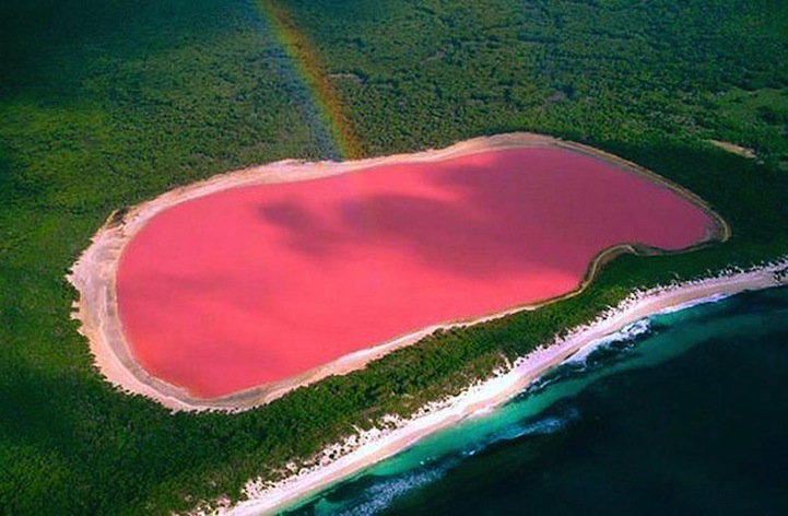
Lago Hillier o “Lago Rosa”, Australia
Este lago localizado en la Middle Island al oeste de Australia tiene un increíble color rosa, que todavía no se ha logrado descifrar de dónde proviene pero los científicos han especulado que podría tratarse de una reacción de la sal marina y el bicarbonato de sodio o de las bacterias halófilas rojas en la corteza de la sal.
Lago Hillier o Lago Rosa Australia
Bahía Halong, Vietnam
Esta bahía se encuentra en la provincia vietnamita Quang Ninh y cuenta con 1600 islas de piedra caliza con vegetación de jungla. Entre estas islas se pueden encontrar lagos escondidos, playas hermosas, grutas y un sinnúmero de cuevas.
Lago Baikal, Siberia, Rusia
Durante el invierno, este lago se congela y gracias al viento, a la diferencia de temperaturas entre el sol y el agua, se forman montículos de hielo color turquesa. Los bloques de hielo puede alcanzar una altura de 50 pies.
Lago Baikal congelado
Wuhua Hai o Lago de Cinco Flores, China
Wuhua Hai, Lago de Cinco Flores o Lago Pavorreal en el valle Jiuzhaigou es un lago superficial llano de árboles que han caído en él. Entre la vegetación, el agua cristalina y los minerales en ella que cambian su tonalidad, el paisaje es un espectáculo de colores.
Wuhua Hai o Lago de Cinco Flores, China
Caño Cristales o Río de Cinco Colores, Colombia
Se dice que este río es el más bello de todo el mundo. La mayor parte del año el fondo del río está cubierto por musgo verde. Entre septiembre y noviembre una especie endémica de plantas del río llamada, macarenia clavigera, se vuelven rojas y junto a la arena amarilla y verde y las tonalidades de agua, el río se convierte en un torrente de colores.
OOPART es el acrónimo en inglés de Out of Place Artifact (literalmente, ‘artefacto fuera de lugar’). Es un término acuñado por el naturalista y criptozoólogo estadounidense Ivan T. Sanderson para denominar a un objeto de interés histórico, arqueológico o paleontológico que se encuentra en un contexto muy inusual o aparentemente imposible que podría desafiar la cronología de la historia convencional. Este video incluye los mapas de Piri Reis, entre otras muchas cosas misteriosas relativas a la historia oculta de la raza humana. Tú juzga si lo crees o no, pero al menos concede el beneficio de la duda.